![]() Δ
Δ
![]() Δ
Δ
![]() Δ
Δ
![]() Δ
Δ
![]() Δ
Δ
![]()
GLEN CLOVA Probably the best known of all the Angus Glens and,
without doubt, having the largest number of high level walking routes, but
where to start ...........
We'll start with an easy route on the west side of the glen. Keep to the left on the public road as you go up the glen and look out for Kilburn Farm on the left and, about a mile past that you will see a sign saying "Minister's Path" at the start of a Land Rover track through the trees. You can park in the bell mouth and then head off through the trees, gradually climbing and then descending into Glen Prosen at Glenprosen village. I think that you can get a cup of tea in the village in the summer before returning to your vehicle by the same route. A relatively easy seven miles. N.B. A new path & bridge is being constructed (2005) which will take the path to the Clova Hotel.
If you travel on up the glen you will arrive at the Clova Hotel - a nice place to stop on the way back for a drink or a meal and, if you have too much to drink, they have bedrooms where you can stay the night and a very basic bunkhouse if money is tight. Head on up the single track road, past the ruins of Glenclova Castle on your right, and, being very careful on the blind corners, after about five miles you will arrive at the car park at the end of the public road. There is no longer a campsite here but I believe the public toilets are still open during the summer months. There is also an information centre in the car park which, most of the time, has a notice board displaying the day's mountain weather and also has a supply of route cards. If you are keen to speak to a ranger and there is not one in the car park then you can usually find Ken Slater at the new Ranger Base in the car park. Those of you who have walked with me over many years will remember Harry Brown from Acharn Farm who took the car park money (ticket machine nowadays!) and who was (and still is) a real character. His wife, sadly, died a few years ago and Harry moved from Acharn to stay in Kirriemuir. He has now re-married.
There are several low-level walks available in the forest at the head of the glen and these are more or less level but can be rough or muddy underfoot. All these walks are well signposted. A new walk is presently being constructed allowing a new circular route up Jock's road, over a new bridge and back by a different route.
Again working anti-clockwise around the head of the glen there are many possibilities for high level walking, scrambling and climbing/abseiling. If you follow the river South Esk south-eastwards from the car park for about three quarters of a mile you will come to a very dilapidated bridge crossing the river. On the other side there is a choice. Head south west towards a very obvious saddle on the skyline (between Driesh and Hill of Strone) and you will have a fairly steep ascent with difficult underfoot conditions. When you reach the saddle you can turn south-east and follow the fence line over Hill of Strone and Cairn Inks (which, according to old superstitions, was the gathering place for a large colony of witches) and, when you are opposite the Clova Hotel, follow the fence that goes off at 90 degrees to the north-east. It is quite a steep and tricky descent but the fact that you can see the hotel tends to spur you on! If, on the other hand, you turn right when you reach the saddle, you can follow the fence, which is quite indistinct in places with only an occasional post, and you will soon be on the large, rounded, top of Dreish (a Munro) and will see the summit cairn enclosing a trig point. You can then keep on following the indistinct fence line to the saddle between Dreish and Mayar where you can follow the Kilbo path right back to the car park. The other alternative, after crossing the old bridge mentioned earlier, is to head for the very obvious corrie (named Winter Corrie after Jock Winter). When you reach the corrie look to the right side of the corrie and you will see a narrow scree slope which you can scramble up to reach The Scorrie and thence to the summit of Dreish. If you go straight ahead in Winter Corrie, or to the left, there are a number of potential routes to the top but all involve a degree of climbing and a degree of exposure. There is another route to reach the Scorrie which again involves a steep scramble near the top. Leave the car park and head westwards past Acharn Farm. Follow the signs for the Kilbo path and cross the river South Esk. About 50 yards farther on turn left and then right to follow the southern edge of the forest as far as it goes and then carry on climbing, keeping well to the right of Winter Corrie and, before long you have reached the last steep scramble to the top of the Scorrie and can enjoy the panoramic views.
The next route around the top of the glen is to take the aforementioned Kilbo path and continue on it up the side of the Shank of Drumfollow and, when the saddle between Dreish and Mayar is reached (there is a large rocky outcrop at this point which is an ideal spot to stop for a break) decide whether to go left for Dreish or right for Mayar. If heading for Mayar you should follow a good fence line for about half a mile then an indistinct fence line for three quarters of a mile to the summit of this Munro. Having "bagged" it there is a choice of returning to the car park by the same route or by walking almost due north and returning by Corrie Fee. The path is a little indistinct in places but then becomes more obvious in Corrie Fee. There is some erosion and a short scramble on this part of the path but the Local Authority are currently working on it and it should be completed around the autumn of 2005. There is a tremendous view from the top of Corrie Fee and the Fee burn meandering along the flat floor of the glen and the terminal moraines are excellent examples of the results of glaciation. There is also a wide variety of very rare alpine plants in this corrie.
The next route is to leave the car park, head past
Acharn farm and follow the sign posts for Jock's Road (named after "Jock
Winter" a local shepherd ). The route is on a Land Rover track
through Glen Doll forest for three miles before it becomes a track on the
open hillside and has been used over the centuries by shepherds, catarans,
whisky smugglers, Jacobites and many others. At the sides of the
track, and in many other similar places in the Scottish Hills, you will find
wood sorrel growing freely. This plant was, and possibly still
is, used to flavour soups and stews and, if simply eaten raw it has a very
refreshing taste. After a mile and a half you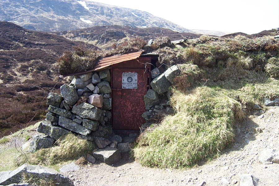
 will
reach "Davy's Bourach" which is a very basic shelter built into the side of
the hill on the left of the path. There has been a shelter here
for many centuries, used mainly by shepherds and travellers crossing from
Glen Shee into Glen Clova, but in the 19th Century it was occasionally used
by botanists who came to seek out the rare alpine plants that grown in the
surrounding hills. It was originally known as "Shieling of
Lunkard" after nearby Cairn Lunkard and then was called "Jock's Hut" (after
the same Jock Winter who gave the track his name and who is said to have
hidden in the hut after angering a local landowner.. It
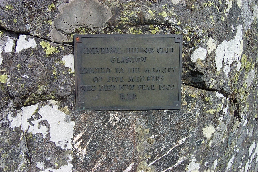
was rebuilt by Davy Glen and his friends in, I think, 1960, following the
death, in the winter of 1959, of five members of a Glasgow hiking club who
perished nearby after losing their way in a snowstorm. This hut
is now maintained by the Forfar & District Hillwalking Club whose motto is
"Far i wi noo" (Where are we now). If you follow the White Water
in a northerly direction from the Bourach you can then ascend the east flank
of the Munro Tom Buidhe. Navigational skills are required,
particularly in poor visibility, as there is no path. From here
it is relatively straightforward to "bag" the adjacent Munro of Tolmount,
which sits on the county boundary, if the weather is good. Most
walkers make a loop westwards and then north eastwards rather than the
straightest route between the two Munros. In poor visibility it
is again advisable to be able to navigate as the path becomes very
indistinct when crossing the burn at the low point. Having
"bagged" Tolmount there is a path, which is again indistinct in places,
which meets Jock's Road near Crow Craigies and can be followed back past
Davy's Bourach. Another option on this route is to leave the
Bourach and follow the path up the side of Cairn Lunkard and on for
approximately half a mile before turning right off the path and heading for
Loch Esk. There is initially no path which, on a good day, is
not a problem but on a bad day it is unless you know what you are doing!
Near Loch Esk is a path, which is quite difficult to find, but which will
lead down to Bachnagairn. This area is part of Balmoral estates
and you might bump into Prince Charles or other "Royals" out for a day's
stalking. From Bachnagairn it is a three mile walk down a very
stony Land Rover track back to the car park.
will
reach "Davy's Bourach" which is a very basic shelter built into the side of
the hill on the left of the path. There has been a shelter here
for many centuries, used mainly by shepherds and travellers crossing from
Glen Shee into Glen Clova, but in the 19th Century it was occasionally used
by botanists who came to seek out the rare alpine plants that grown in the
surrounding hills. It was originally known as "Shieling of
Lunkard" after nearby Cairn Lunkard and then was called "Jock's Hut" (after
the same Jock Winter who gave the track his name and who is said to have
hidden in the hut after angering a local landowner.. It
was rebuilt by Davy Glen and his friends in, I think, 1960, following the
death, in the winter of 1959, of five members of a Glasgow hiking club who
perished nearby after losing their way in a snowstorm. This hut
is now maintained by the Forfar & District Hillwalking Club whose motto is
"Far i wi noo" (Where are we now). If you follow the White Water
in a northerly direction from the Bourach you can then ascend the east flank
of the Munro Tom Buidhe. Navigational skills are required,
particularly in poor visibility, as there is no path. From here
it is relatively straightforward to "bag" the adjacent Munro of Tolmount,
which sits on the county boundary, if the weather is good. Most
walkers make a loop westwards and then north eastwards rather than the
straightest route between the two Munros. In poor visibility it
is again advisable to be able to navigate as the path becomes very
indistinct when crossing the burn at the low point. Having
"bagged" Tolmount there is a path, which is again indistinct in places,
which meets Jock's Road near Crow Craigies and can be followed back past
Davy's Bourach. Another option on this route is to leave the
Bourach and follow the path up the side of Cairn Lunkard and on for
approximately half a mile before turning right off the path and heading for
Loch Esk. There is initially no path which, on a good day, is
not a problem but on a bad day it is unless you know what you are doing!
Near Loch Esk is a path, which is quite difficult to find, but which will
lead down to Bachnagairn. This area is part of Balmoral estates
and you might bump into Prince Charles or other "Royals" out for a day's
stalking. From Bachnagairn it is a three mile walk down a very
stony Land Rover track back to the car park.
The next walk is to turn left when leaving Glen Doll car park and cross the road bridge over the river South Esk before immediately turning left again and following the Land Rover track which runs parallel to the river. Follow this track past Moulzie, cross the river by the footbridge and continue up the opposite bank to Bachnagairn. At Bachnagairn you will see the ruins of two houses (one more obvious than the other) and rumour has it that there is a ghost in the vicinity of one of the houses. She is known as "The Grey Lady" and the story of how she came to haunt this area is too long to go into here. Cross the river by the "Roy Tait" memorial bridge (Erected by family and friends in memory of Roy - who died on Lochnagar) and follow the zigzag path to the pony huts at Sandy Hillock - an ideal spot to stop for a break, particularly if the weather is bad. There was a lookout point near here during WW2 which was continuously manned and parts of which can still be seen. There are several options at this point. If you head westwards on the Land Rover track passing by the pony huts you will soon reach the summit of Broad Cairn (Munro). There are some tremendous views of Loch Muick and Lochnagar from the track but walkers should be aware that as you near the summit it is very rocky underfoot with some large, unstable, boulders. As you head westwards from Broad Cairn it can initially, be difficult to pick up the track heading to-wards the next Munro, Cairn Bannoch, if visibility is bad. After bagging Cairn Bannoch head westwards and then southwards past Fafernie. In the area between Fafernie and meeting up with Jock's Road the path is very indistinct and at times non-existent. There is an option for the very fit to cross Jock's Road and bag Tolmount and Tom Buidhe. Head back by Crow Craigies and Davy's Bourach to the car park. This a long 14 mile walk (16 miles if Tolmount and Tom Buidhe are included) in a remote area and, as with all high level walks, it should not be undertaken without good equipment and good navigational skills. Another option, after leaving the pony huts at Sandy Hillock, is to head eastwards then, after a couple of hundred yards, turn left on a narrow path which will take you by Corrie Chash and down a steep, stony, path, known locally as "The Streak of Lightning" to the shores of Loch Muick. This area is really not part of the Angus glens so I will mention briefly that you can head westwards to the Dubh loch, round the western end of Loch Muick to the Glas-alt-Shiel and thence to Lochnagar or stay on the south east side of the loch to-wards the visitor centre and sharp right before the visitor centre to return to Glen Doll by the Capel Mounth path. The next option, after heading eastwards from the pony huts, is to stay on the Land Rover track and, after about two miles and just before the track starts to descend to the shores of Loch Muick, cut off cross-country to the right and, using a compass, navigate south-eastwards to pick up the Capel Mounth path which, at this point, is a Land Rover track. Turn right on this track and, as it starts to descend steeply into Glen Doll, it becomes a footpath which brings you out on the Moulzie track about a mile from the car park.
The next walk of interest starts from the Clova Hotel - there is a public car park with toilets just across the road from the hotel. Walk up the south-east side of the hotel, through the trees, cross the burn and you will soon find yourself on the open hillside. Follow the track uphill, fairly steep and muddy in places (but due to be repaired/upgraded in 2006), and, after a mile and a half, you will arrive at Loch Brandy. This can be a beautiful place on a bright sunny day but a very foreboding place on a dark day with the mist down. The unfit walker can, at this point, turn around and head back to the hotel. The fitter walker can continue up The Snub on the west side of the loch - this is a short but very steep climb. Walk by the cairn at the top of the climb and follow the edge of the cliffs at the back of the loch, downhill, cross a wet, boggy area at the low point and pick up the Land Rover track which will take you to the top of Green Hill. Just before the top you can cut off to the right and pick up a track down the east side of the loch and back to the hotel. Everyone should be aware that the cliffs at the back of the loch are potentially very dangerous and no-one should venture too close to the edge. There is one area of cliff where you will see that a large part is coming away from the main face! If you continue on the Land Rover track past Green Hill for less than half a mile you can cut off to the left on the right of way track that leads over to Glen Esk. This is a very faint path but is characterised by occasional edge-on flat stones which were probably put there many centuries ago by glen folk travelling from glen to glen. En route to Glen Esk the track goes over Muckle Cairn and, on the south-east flank of this hill, is the remains of a Wellington bomber which crashed during WW2. Another option, after passing Green Hill at the back of Loch Brandy, is to keep on the Land Rover track and it will take you down the west side of Loch Wharral and out onto the glen road at Wheen farm. You then have a three mile walk back to the car park at the Clova Hotel and, by the time you get there, you will have worked up such a drouth that you will feel obliged to go in to the hotel for a "quick one". Within the next couple of years the path to Loch Brandy is to be repaired and upgraded!
Home Δ Personal Δ Hillwalks Δ Hill Safety Δ Photographs Δ Dominie's Bairns
© hillwalking@gordonsnedden.co.uk