![]() Δ
Δ
![]() Δ
Δ
![]() Δ
Δ
![]() Δ
Δ
![]() Δ
Δ
![]()
|
GLEN ESK The last of the Angus glens and the most easterly/northerly it has a character all of its own. In olden times it was known as the "Glen of the rowans" because of the number of those trees from the bottom of the glen to the top. The rowan tree was very important to the glen people, not only in this glen but elsewhere in Scotland. The rowan has the ability to ward off evil spirits and, even to-day, you will find rowan trees in many a Scottish garden. I've had a rowan tree in my garden for most of my life and have had no problem at all from evil spirits! But, although we may joke about it nowadays the old Scots glen folk took it very seriously indeed. If a baby was about to be born in the glen then the bed where the mother was to give birth was strewn with leaves or twigs from the rowan tree so that the newborn baby would have immediate protection. In some glens the baby's first nappy was burned on a fire of rowan wood. If any of the glen folk's animals were sick, or were barren, they would make a garland of rowan twigs and hang it around the animal's neck. Nowadays Glen Esk should be called the "Glen of the Silver Birches" because that is the tree that you will see from the bottom to the top of the glen. Again I will take the walks in this glen from south to north.
If you drive up the
glen, past "The Retreat" where you can not only have
a cup of tea and some home cooking but also visit their
local museum, to the head of the glen, you will find a
public car park (but no public toilets). Turn
left after leaving the car park and walk back down the
tarred road for about half a mile then turn right and you
will find a bridge across the river
North Esk.
Alternatively walk on for another half mile and turn right.
Either way you will arrive at Gleneffock farm.
Go through the farm and take the obvious track up the hill
to the right (Cairn Caidloch), continue along the
Land Rover track, over Burnt Hill
with its trig point
and down the path to Inchgrundle. Return
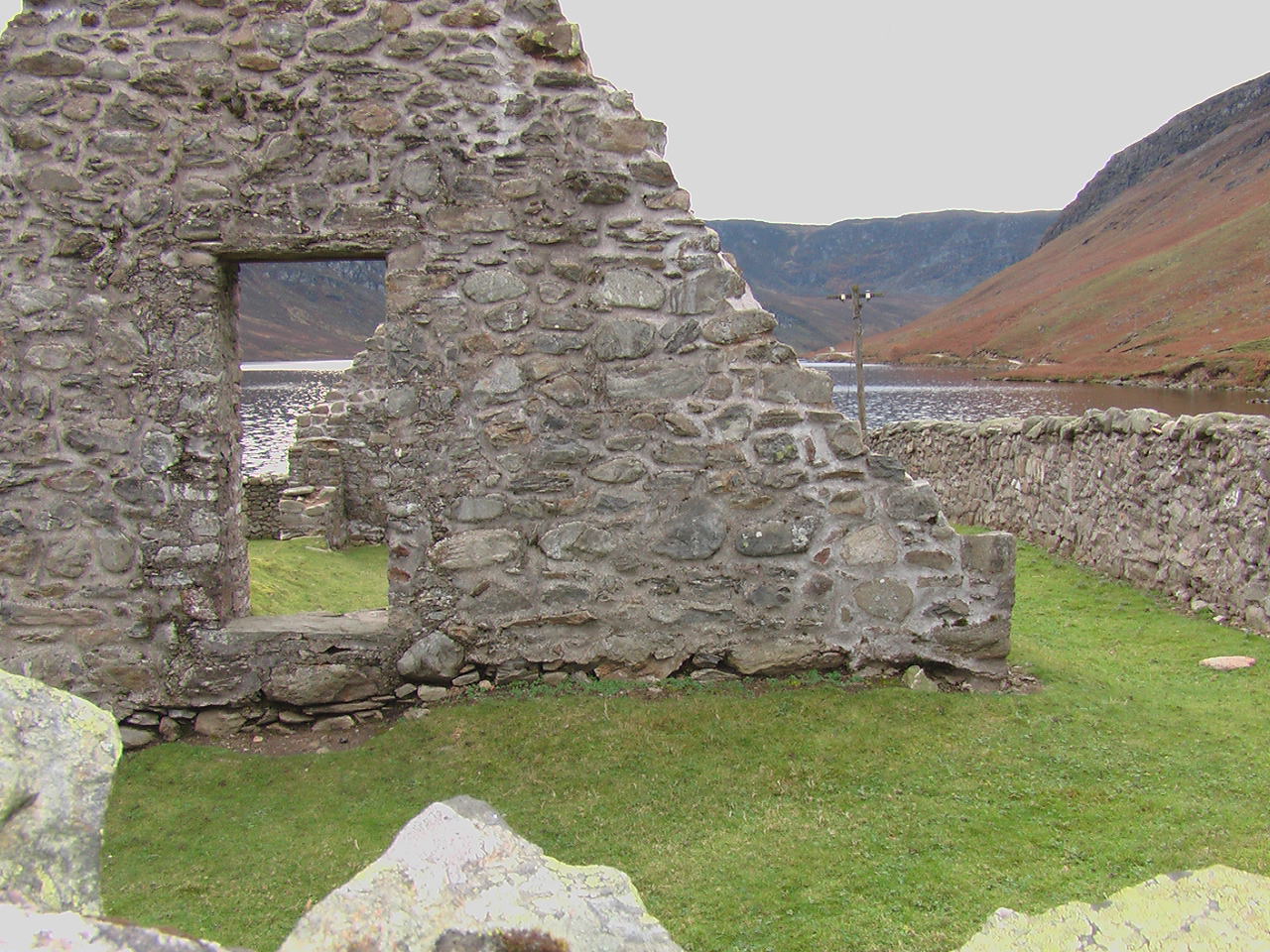
by the north side of Loch Lee and, at the east end of
the loch you will find the ruins of
Lochlee Church
and its graveyard. This graveyard is well worth
a visit. On the right as you go in the
gate is a stone in memory of
Jean Cattanach with an
inscription that reads, “This stone was erected by Mr Alex
Ross, schoolmaster at Lochlee, in memory of Jean Cattanach,
his spouse, here interred, who died May, 1779, aged 77 years
and, directly facing it, is another stone in memory of her
husband Alexander Ross, born in 1699, who, in the 18th
century, was headmaster at Lochlee
School - just
across the road from the church. He was also an
author and a poet and was known throughout Scotland.
He always wrote in the Scots dialect and there is a poem on
his gravestone which no-one, other than a Scot, would
understand. It reads “How
finely nature aye he paintit, of sense in rhyme he ne'er was
stintit, an to the heart he always sent it, wi micht and
main. An no ae line he ere inventit, need ane
offen.".
His best known work was the story of
Lindy and Nory
which is sub-titled “The fortunate shepherdess” and I
will quickly tell you the story. I may get
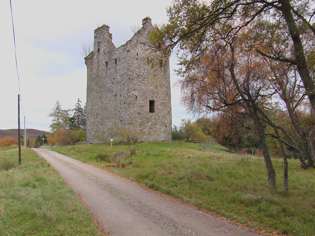
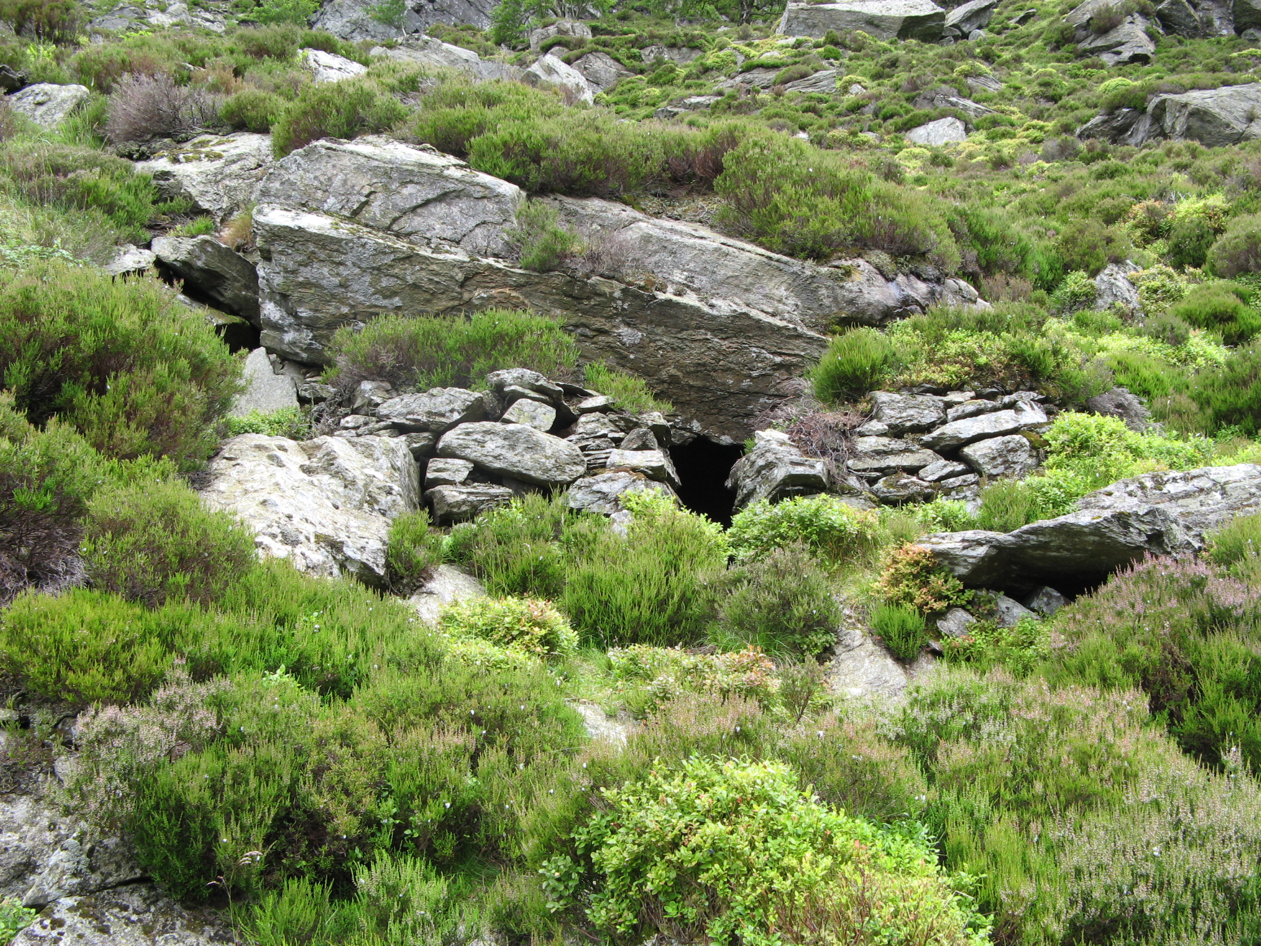
slightly About half a mile past the graveyard, still heading for the car park, is Invermark Castle (ruin) which was built in 1526 by the Lindsays of Edzell Castle. An interesting feature of the castle door which is about 20 feet above ground level. The car park is reached a few hundred yards past the castle. The next walk of interest, going anti-clockwise round the head of the glen, is to head west from the car park, past the castle and the graveyard, up the side of Loch Lee and, where the track goes off to the left to the shepherd's house at Inchgrundle, you carry straight on. After a mile and a half you will see a bridge on your left crossing the Water of Lee. Cross this bridge and head off along the path to the Falls of Unich. Head on up an increasingly steep path and you will pass an outcrop of mica schist. This is a very interesting and attractive stone and there is plenty of it so why not take a small piece as a souvenir! Carry on up this track and, as the ground starts to level off, you will find the double waterfalls of the Falls of Damff. You can go right down to the falls but be extremely careful as this is a dangerous spot and I would certainly never take children down to it. A few hundred yards farther on from the falls is a new bridge crossing the river. If your navigational skills are poor then follow the riverbank south-westwards for about a mile and you can pick up a Land Rover track on your left. Follow this track eastwards to Cairn Lick and, on the high point, there is a spectacular view down the length of Loch Lee. Descend on this track to-wards Inchgrundle. pausing halfway down to look down to the left into the inky black waters of Carlochy. From Inchgrundle it is an easy walk back to the car park.
For the next walk
head west from the car park for a couple of hundred yards
and take the track on the right just past the church.
Go through the five bar gate and head on on level ground.
As you approach the next, larger gate, look at the sides of
the track and you will find quite a large area of bog
myrtle. This plant was used for centuries to
ward off flies, midges, etc. and, if you rub some of the
leaves and have a sniff, you will understand why!
Continue on this track for a mile and a half and, on the
right of the track there is a very small hillock with a
stone on the top. I heard a story, many years
ago, and I cannot vouch for its truthfulness, that this
stone marks the spot where, in the 19th century a travelling
woman (tinker) was murdered by her husband. The
story goes that they had walked over the mounth road from
Deeside and all the way across she had been "Nipping his
heid". Just at the spot where the stone is he
could stand it no longer and put his hands around her neck
and strangled her. The story goes that he left
her body and gave himself up to the authorities in nearby
Brechin (getting a bit unbelievable now!) and was
subsequently hanged for his crime. The local
glen folk buried the victim where she lay and erected a
small stone. It is possible that this is just a
boundary marker but I prefer the "Crime of passion"
explanation! Half a mile
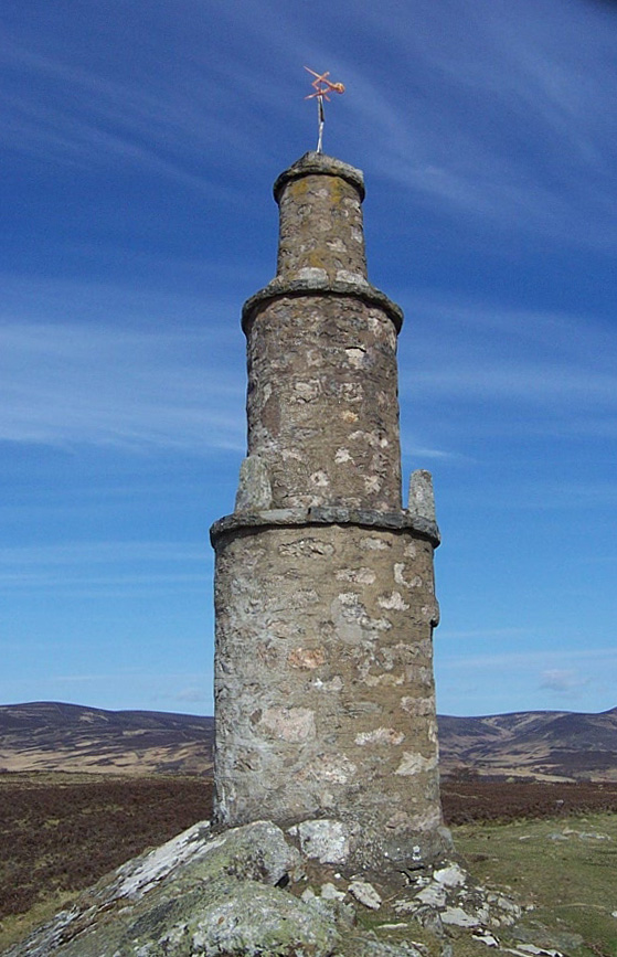
As you drive
back down the glen you will see
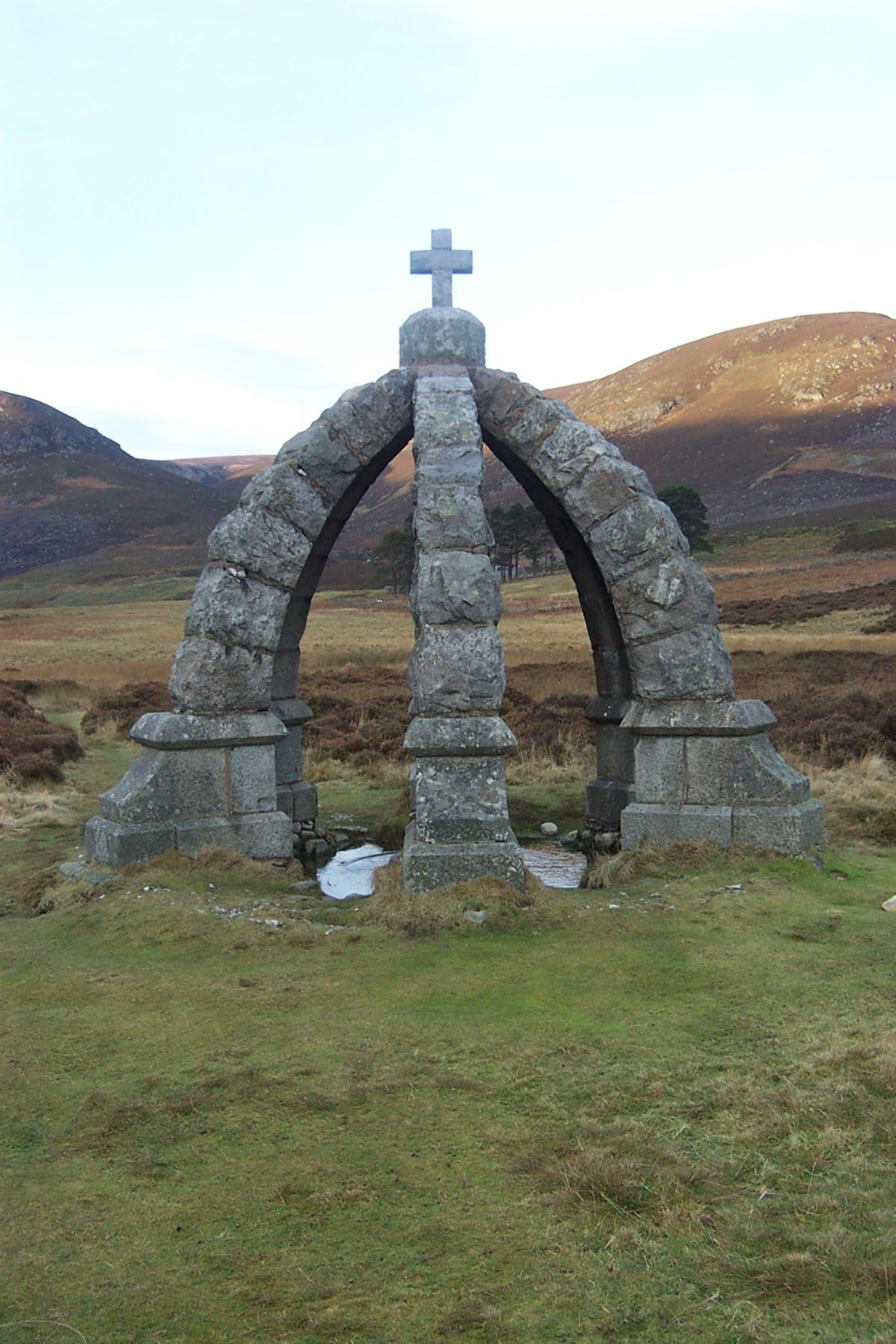
Rowan Hill on your
left. On its top is a cone-shaped tower which
was built in memory of Lauderdale Maule
who died in
the Crimean War. It was ordered to be built by
his brother Fox Maule,
Earl of Dalhousie, and
is said to be built on the spot where they said their
goodbyes as Lauderdale went off to the war (In those
days the main glen road went over
Rowan Hill).
I have heard that near to the monument is the ruin of a
"Whisky Bothy" where illicit (and duty free) whisky was
produced but I John Angus, who lived in Glen Esk and died about the mid 1980s, wrote a poem about this glen .... Genesis They say, when god the father made the earth, He rolled between His palms its rocks and clays Then breathed upon it to give life a birth. And it was done, and set into its place. But ere he sent it spinning into space he gave it one last little pat in love. And there the mark remains, upon the face of Angus - the thumb the Tay, and then above, Glens Isla, Prosen, Clova, Esk, these four God's fingers fashioned, and his palm, Strathmore. Four fair green glens reach far into the west, And of them all, the loveliest and best In Esk - Glen Esk by loving gesture given, God's little finger left the mark of heaven. A fitting tribute to a beautiful glen.
|
Home Δ Personal Δ Hillwalks Δ Hill Safety Δ Photographs Δ Dominie's Bairns
© hillwalking@gordonsnedden.co.uk